 Cloud M&F Engineering ConsultancyTRAFFIC STUDIES DIVISION
Traffic Studies · TIS
An approved traffic study
that unlocks your permit and your project.
We count traffic in the field, model it with world-class software, then design your access, parking and junctions — so your permit clears smoothly and your customers arrive with ease.
درجة 2Balady 2nd-degree classified6Cities across the KingdomISO 39001Road traffic safety certified24/7Field traffic operationsAmong our works: Qiddiya City roads, 24/7
01Scope & importance
What our traffic studies cover
We deliver accredited traffic studies and Traffic Impact Studies (TIS) — required by authorities to permit many commercial and development projects. From movement-data collection and modeling to intersection, signal, access and egress design and traffic management plans, we serve individuals, companies and developers across Dammam, Riyadh and the entire Kingdom, with experience on major national projects.
Accredited studies that speed up your permitAdvanced, data-driven traffic modelingExperience on major national projectsWe serve companies and developers in Riyadh and nationwide
02How it works
We see the problem before you queue in it.
Three scenes from our daily work — junction to gate.
01
Connected signals, smarter junctions.
We analyze surrounding junctions, retime signals and redesign lanes — adaptive control that reads live demand, raising and improving the level of service on the road.
02
Smart, sustainable — not necessarily complex.
Not every traffic problem needs costly widening: sometimes a well-designed roundabout, retiming or circulation redesign — simple, sustainable fixes that restore flow at minimal cost and impact.
03
Securing access — per the Saudi Highway Code.
A parallel deceleration lane with code-compliant taper and length, protected by a marked gore island — your customer leaves the mainline safely and reaches your gate without impeding through traffic.
03Study levels
Three levels — by peak-hour trips.
Scoped free of charge before we start.
LEVEL 01
Level 1
Under 500 peak-hour trips
Access study (entrances & exits)
Gas stations, showrooms, small commercial buildings and restaurants
LEVEL 02
Level 2
500 – 2,000 peak-hour trips
Focused TIS with capacity & level-of-service analysis
Commercial complexes, markets, office towers and public parks
LEVEL 03
Level 3
Over 2,000 peak-hour trips
Comprehensive TIS with full network modeling & simulation
Major malls, master plans, hospitals and national projects
04Methodology
From data to approval — step by step.
- 01
Movement-data collection
Field traffic counts and analysis of the existing conditions around the project.
- 02
Demand forecasting & modeling
Estimating project-generated traffic and modeling it with specialized software.
- 03
Impact assessment & solutions
Assessing network impact and designing access, egress, parking and intersections.
- 04
Traffic management plan
Preparing traffic management and road-safety plans for operation and construction.
- 05
Report and approval
A technical recommendations report and coordination with authorities through approval.
05From our files
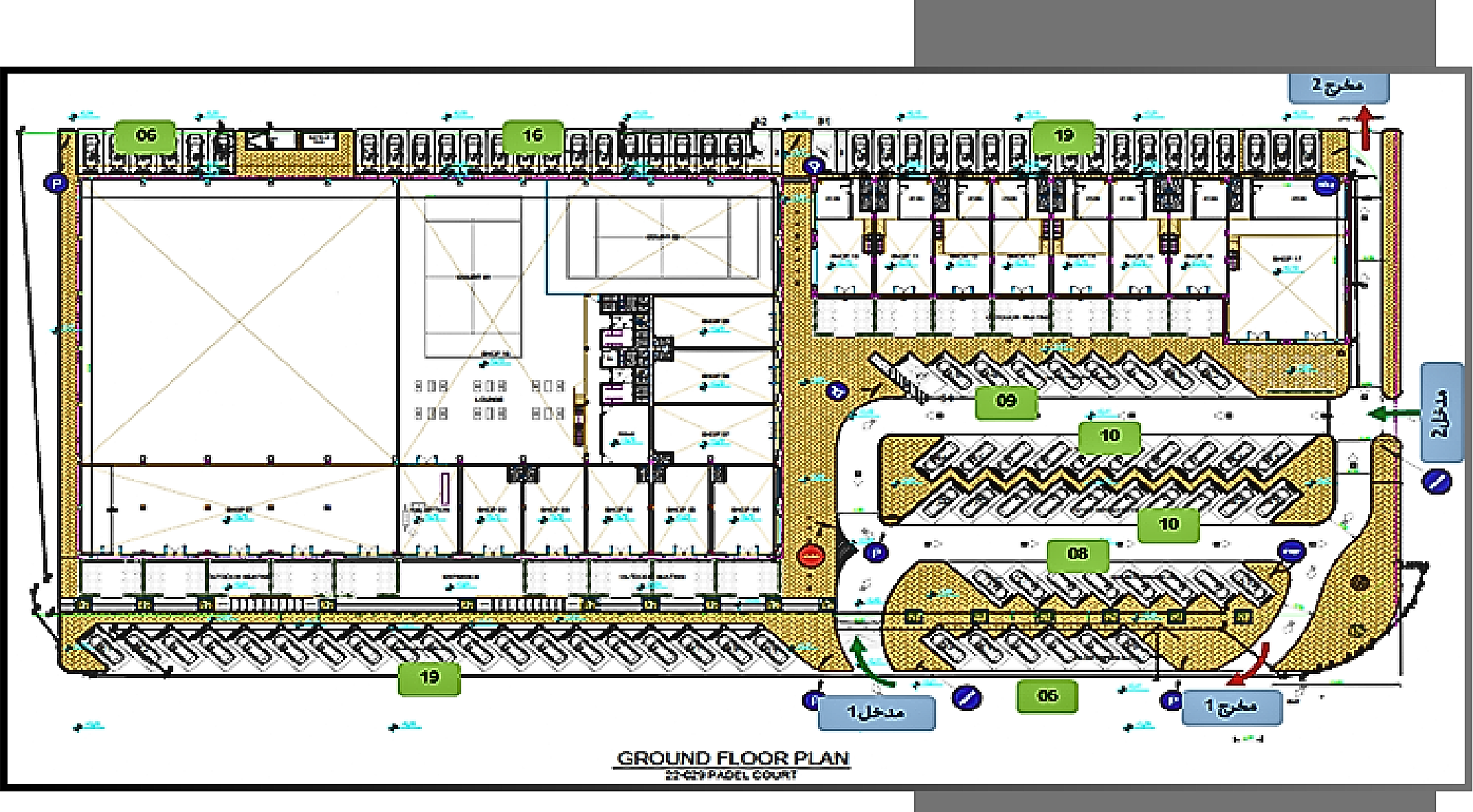
The plan comes alive: simulation on the drawn circulation.
A faithful re-drawing of an approved study plan (Al-Ahsa commercial complex): vehicles keep to the aisles, park and leave, and exit through the drawn gates.
1Entrances & exitsFour studied gates separating in from out, eliminating conflicts.
2Internal circulationCalculated widths and directions keep flow smooth — no backtracking.
3Angled parking rowsThe stall angle eases entry and raises capacity on the same footprint.
4Pedestrian separationWalkways keep visitors safely apart from vehicle movement.
06Division services
The technical and field services in detail.
From designing and permitting the diversion, to running it in the field, to measuring traffic, auditing safety and treating crash sites — each service with its model and deliverables.
01
Traffic diversion & management plans (TMP / TDP / TCP)
We design the diversion across its four standard areas — advance warning, transition, work space with its buffer, and termination — so drivers know what is ahead hundreds of metres in advance and reach the works already slowed and safely shifted into the new lane.
- ▪A complete signing sequence: staged warning signs, graduated speed reduction, lane-closure and mandatory-direction signs, and an electronic arrow board at the taper.
- ▪Taper length and sign spacing calculated from design speed and lateral shift — never estimated.
- ▪Separation and protection: cones, delineators, concrete or water barriers, flashing lamps and temporary lighting for night works.
- ▪Continuity for pedestrians and people with disabilities via safe alternative crossings, plus access to neighbouring properties.
- ▪Phased works planning, an emergency plan, and full reinstatement of normal traffic afterwards.
Deliverables:Permit-ready CAD drawingsAmana, Police & RGA approvalRisk assessment & method statementSign & device schedules
02
On-site traffic management & implementation
A plan on paper stops no crash — implementation is what protects people. We put certified marshals on site in hi-vis kit with radio-synchronised STOP/GO paddles, running single-lane shuttle operations and directing traffic in real time at gates, junctions and work zones.
- ▪Marshals trained in queue management and priority for emergency and crossing traffic.
- ▪Radio coordination between both ends prevents opposing movements inside the single lane.
- ▪Daily installation and maintenance of every control device: cones, barriers, signs, lamps and night lighting.
- ▪A supervision vehicle with warning beacons patrols the site and intervenes on any failure.
- ▪Recovery and towing equipment clears broken-down vehicles off the running lane before they become a hazard or a bottleneck.
- ▪Photo-documented daily operations reports, and safe reopening at the end of each shift.
Deliverables:24/7 field crewsCertified marshals & compliant kitBreakdown recovery & towingPhoto-documented daily reports
Live reference: Qiddiya City roads — round-the-clock traffic operations, rotating night and day shifts, gate and route management with daily documentation.
03
Traffic counts & surveys
No study is stronger than its data. We measure traffic in the field three complementary ways — AI vision cameras, pneumatic-tube automatic counters and certified manual counts — then audit and reconcile the results into dependable peak data your model and design rest on.
- ▪Computer-vision cameras classify vehicles and count pedestrians and cyclists around the clock.
- ▪Pneumatic-tube counters log volume, speed and axle classification for a full week — the basis of speed and link studies.
- ▪Manual counts by field observers capture junction turning movements at peak hours, where automated devices cannot separate movements.
- ▪Supporting surveys: journey times, queue lengths, parking occupancy and pedestrian crossing demand.
- ▪Data auditing and outlier treatment, exported ready for the modelling software.
Deliverables:Audited peak dataTurning-movement matricesSpeeds & vehicle classificationModel-ready survey report
04
Road Safety Audit (RSA) — the five stages
An independent, systematic examination by a team that had no part in the design, asking one question: where could someone be hurt here? We apply the recognised international methodology across the project's five stages and deliver risk-ranked findings, each with an actionable treatment.
- ▪Team independence is essential — an audit is neither a design review nor a compliance check, but a hunt for risk from every road user's perspective.
- ▪Site inspection by day and by night, in varied traffic and weather, from the driver's, pedestrian's, cyclist's and disabled user's viewpoint.
- ▪Each finding classified on a risk matrix (likelihood × severity) to prioritise treatment.
- ▪Covers work zones and existing roads too, not only new projects.
The audit process per international practice:
- 01Independent teamSafety and design expertise, unrelated to the project
- 02Background dataDrawings, speeds, volumes, crash history
- 03Commencement meetingScope, stage and deliverables agreed
- 04Document reviewDrawings and details checked against safety principles
- 05Site inspectionDay and night, from every user's perspective
- 06Audit reportRisk-ranked findings with specific recommendations
- 07Completion meetingFindings discussed with designer and client
- 08Response & close-outDecision per finding and follow-up to closure
Deliverables:Risk-ranked audit reportSpecific treatmentsCommencement & completion minutesClose-out tracking
05
iRAP assessment & ViDA star rating
We measure the safety built into the road itself — not the behaviour of its drivers. We survey 50+ safety attributes along the corridor and analyse them on the ViDA platform to the international iRAP methodology, producing a 1–5 star rating for each road-user class separately.
- ▪Separate ratings for vehicles, pedestrians, cyclists and motorcyclists — a road can be 5-star for cars and 1-star for people on foot.
- ▪A Safer Roads Investment Plan ranking treatments by lives saved per riyal spent.
- ▪Impact measurement by re-rating after implementation and comparing before/after stars.
- ▪Aligned with Vision 2030 targets and the UN Decade of Action for Road Safety.
Deliverables:Star rating per user classPrioritized investment planRoad attribute reportBefore/after impact
06
School-zone safety
A child cannot judge a car's speed and cannot be seen from behind a parked vehicle — so asking drivers to pay attention is not enough. We design the street to force slowing and remove the child–vehicle conflict altogether, delivering a complete school zone per municipal requirements and the Saudi traffic-control manual.
- ▪Graduated speed calming before the gate, with a school speed limit backed by part-time flashing beacons active only at arrival and dismissal.
- ▪Raised crossings (speed tables) with zigzag markings that ban parking and overtaking near the crossing and preserve sight lines.
- ▪Physical separation of people and vehicles: raised footways, guard railing at the gate and bollards preventing footway parking.
- ▪A dedicated drop-off/pick-up bay sized for the dismissal peak, eliminating double parking and children weaving between cars.
- ▪Safe Routes to School analysis and sight-distance checks at gates so child and driver can see one another.
- ▪An arrival/dismissal peak management plan agreed with school administration, with a trained crossing supervisor where needed.
Deliverables:Complete school-zone layoutRaised crossings & beaconsDrop-off / pick-up bayArrival & dismissal plan
07
Incident data & black-spot management
Crashes are not randomly scattered — they repeat at specific locations for engineering reasons that can be found and fixed. We build a unified crash database, identify clusters statistically, investigate the root cause at each site, rank treatments by safety return on cost, and measure the effect after implementation.
- ▪Consolidating crash records from their sources, correcting coordinates and mapping them in GIS.
- ▪Cluster identification by crash rate per distance/volume and a severity index weighted for fatalities and serious injuries — not raw counts alone.
- ▪Field investigation of each site's root cause: geometry, operating speeds, sight distance, control devices and conflict patterns.
- ▪Treatments ranked by lives saved per unit cost, with short- and long-term options.
- ▪Post-implementation impact measurement using before/after comparison and a periodically updated dashboard.
Deliverables:Database & black-spot mapRoot-cause investigationsPrioritized treatmentsBefore/after impact
07New service line
Smart-city systems.
We extend our field operations expertise into systems that run your city and project intelligently.
Adaptive signal control
Signals that read live demand and retime themselves.
Intelligent transport systems
Sensors, VMS and central integration for the network.
Urban digital twin
A living model of the city to test decisions first.
AI counts & sensing
Vision analytics counting vehicles and pedestrians 24/7.
Smart parking
Live guidance to free bays — happier visitors, faster turnover.
Traffic control centers
Operations rooms running signals and incidents 24/7.
08Toolset
Global software, local know-how.

PTV VISSIM · Visum
Microsimulation & demand modeling

SIDRA Intersection
Intersection capacity

Synchro · SimTraffic
Signal timing

HCS — HCM
Capacity & LOS

TransCAD
Strategic planning

Civil 3D · AutoCAD
Geometric design
09Approvals
Approval-ready with the authorities.
Balady-classified (2nd degree), SCE-licensed.
 Ministry of Transport
 Balady
 Saudi Council of Engineers
 RC for Riyadh City
 RC Jubail & Yanbu
 Eastern Province Municipality
 Al-Ahsa Municipality
 Riyadh Municipality
10Track record
Projects that speak for us.
From Qiddiya 24/7 to malls, hotels and factories — six cities.

Qiddiya City Core Roads
Qiddiya Investment Co.
Round-the-clock traffic operations on the City Core Roads (Package 3) of one of Saudi Arabia's largest entertainment developments: 3 signalized junctions and 3 access gates run by a 39-person team across three shifts, with violation monitoring, incident response and photo-verified daily reporting — ISO 39001 compliant.
24/7 Traffic Management & Road SafetyRiyadh18 شهراً
Al-Mursalat Park — Green Riyadh
Royal Commission for Riyadh City
A Level-2 study for Al-Mursalat Park under the Green Riyadh program: a 99,230-sqm site with sports zones, arts & culture, F&B and open lawns — planning 308 parking spaces (VIP, off-street and on-street) and organizing the park's entrances and 28,116 sqm of perimeter roads.
Traffic Study — Level 2Riyadh99,230 م²90 يوماً

Al-Rabow Hotel — Al Othaim
Al Othaim Co.
A traffic impact study for a new 32,000-sqm hotel in Riyadh: traffic analysis and optimization of surrounding urban roads, including signal-timing adjustments and the redesign of key intersections to improve flow and serve the hotel's access and drop-off.
TIS — Level 2Riyadh32,000 م²75 يوماً

Ajyal Project — Tamimi Markets
Tamimi Markets
A two-phase study in the Ajyal district: Phase 1 for the Tamimi supermarket (3,000 sqm) with its parking and access, Phase 2 for a 37,000-sqm commercial boulevard — organizing entry, exit and parking across the full 40,000-sqm site.
Traffic Study — Level 2Dhahran40,000 م²مرحلتان: 20 + 45 يوماً
Ajyal Shopping Center
Modern Homes
A TIS for a new shopping center in Dhahran: analysis and optimization of major surrounding urban roads, with signal-timing adjustments and the redesign of key intersections to improve flow and reduce congestion around the center.
TIS — Level 2Dhahran15,000 م²60 يوماً
Covent Garden Mall
ETAR Al-Arabi
A TIS for a new 12,012-sqm mall in Dammam: analyzing and optimizing the surrounding network, including signal timing and the redesign of the key intersections feeding the project for smooth visitor access.
TIS — Level 2Dammam12,012 م²85 يوماً

Al Muraykabat Plaza
NUBUL Design & Build
A restaurants-and-showrooms complex in Al Muraykabat, Dammam, on Othman ibn Affan Road near King Fahd Specialist and Children's Hospitals — a Level-2 study of its access and parking, delivered in 35 days.
Traffic Study — Level 2Dammam6,810 م²35 يوماً
Oasis Business Tower
Irtikaz Riyadh Real Estate
A multi-storey business tower on Riyadh Road, Hofuf — offices, exhibition areas, shops, restaurants and cafés — with a Level-2 study of access, drop-off and parking delivered in 35 days.
Traffic Study — Level 2Al-Ahsa7,495 م²35 يوماً
Commercial Complex — Dammam
Private Developer
A TIS for a major 49,870-sqm commercial complex in Dammam: analyzing generated traffic and optimizing surrounding arterials, signal timing and intersection design to serve the project's retail scale.
TIS — Level 2Dammam49,870 م²110 أيام
Specialized Cables Factory
Royal Commission — Yanbu
An industrial TIS for a 63,500-sqm cables factory in Yanbu, approved by the Royal Commission for Jubail & Yanbu: organizing truck entries and exits on Al-Thamin and Al-Sabih roads and optimizing surrounding urban traffic.
Industrial TIS — Level 2Yanbu63,500 م²95 يوماً

Gas Stations — AlDrees · Orange · Transit
AlDrees · ANAT · Almadar Alshamali
A series of Level-1 access studies for full-service gas stations across the Eastern Province, Al-Ahsa and Riyadh: designing entries, exits, in-station circulation, pump layout and parking — one (Transit station on Dhahran Rd, Al-Ahsa, 13,481 sqm) delivered in just 12 days.
Access Studies — Level 1Eastern · Al-Ahsa · Riyadhمن 12 يوماً
Geometric Access Design — Riyadh Road
Almutlaq Real Estate Investment
Design and connection of an entrance/exit on Riyadh Street, Dammam, per Ministry of Transport specifications: topographic survey, natural ground levels and full geometric design — for a highway-front site with no service road, securing safe access.
Geometric DesignDammam25 يوماً
Hyper Mall — Al-Ahsa
Private Developer
A hyper mall in Al-Ahsa — a study focused on entrance/exit design and in-site circulation and parking, delivered and approved in 18 days.
Traffic Study — Level 2Al-Ahsa4,280 م²18 يوماً
Commercial Building — Jawatha
Private Developer
An 8,552-sqm commercial building in Al-Ahsa — an access and in-site circulation study ensuring smooth entry, exit and parking.
Traffic Study — Level 2Al-Ahsa8,552 م²65 يوماً
Shopping Mall — Al-Ahsa
Private Developer
A new shopping mall in Al-Ahsa — a TIS covering surrounding-network analysis, signal timing and redesign of the feeding intersections.
TIS — Level 2Al-Ahsa8,730 م²70 يوماً
Events & Conference Traffic
KJO · Linde · Mutmainna
Planning and field operations for crowd and traffic management at major conferences and exhibitions: IPTC and Saudi National Day in Khafji (KJO), the KFUPM Energy Exhibition (Linde) and the Safety & Security Exhibition in Riyadh — routes, parking, signalized intersections and emergency plans.
Crowd & Traffic Management PlansKhafji · Riyadh
FAQ
What project owners ask.
When does my project need a Traffic Impact Study (TIS)?
Municipalities and authorities require it to permit large commercial projects (malls, showrooms, stations, complexes) that generate significant traffic.
Do you serve companies and developers in Riyadh?
Yes, we prepare traffic and impact studies for companies and developers in Riyadh, the Eastern Province and across the Kingdom.
How long does a study take?
Typically two to several weeks, depending on project size, number of intersections, and authority approval times.
Does it include a traffic management plan (TMP)?
Yes, we prepare temporary traffic management plans to ensure safety and flow during construction.
Related services
One engineering system.
Does your project need a traffic study?
We scope your required study level free of charge — Kingdom-wide.